
Alpine Tips

Are you more likely to get lost going up or going down?
Are you more likely to get lost when you are climbing up a mountain, or heading down?
Quick question: Are you more likely to get lost going up a mountain, or on your way down?
Answer is: going down. This is true for several reasons.
Terrain features like ridges and gullies diverge you go downhill away from a summit, magnifying the mistake of choosing the wrong feature.
On the way down, you’re physically and mentally more tired, so you're more prone to navigation errors.
Returning to your last known point (usually the best way of getting unlost) usually involves going back uphill, which sucks. It's easier to keep going down, which can turn slightly lost into completely lost.

What's “shaded relief” on a contour map?
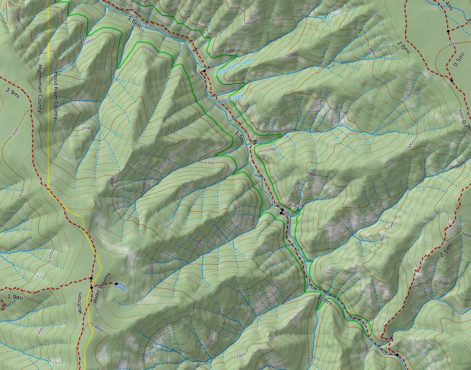
“Shaded relief” is a bit of cartographic wizardry that tricks your eye and brain into seeing the landscape in almost 3-D. It makes seeing terrain features like ridges and gullies much easier than with a standard topographic map. It's quick and free to print your own shaded relief maps with Caltopo.
Shaded relief, also known as terrain shading, is a very clever way to make contour maps appear more three dimensional. With shaded relief, terrain features such as ridges and gullies appear much more prominent and recognizable. The shading works some magic between your eye and your brain to make what you're looking at appear 3D. It's really quite amazing!
Below is an example of the Eagle Creek Trail in the Columbia River Gorge in Oregon. (The red line is the wilderness boundary.) This first map is from the standard USGS 7 1/2 minute topographic map, with no shaded relief. At first glance, most people will see this as pretty much a spaghetti pile, with no obvious ridges or gullies visually jumping out. (Yes, if you know a bit about reading contours you can probably make out some of the terrain features, but that’s a different topic.)

Now, here’s a screen grab of the exact same area, with about 20% shading added to the map.
Magic! Notice how the ridgelines and the stream drainages are much more obvious? Most people find this map MUCH easier to read.

Before modern mapping software, cartographers tried to achieve this by using hand drawn shading. This was incredibly labor-intensive, but achieved some beautiful examples of cartographic art. Here's an example of some amazing Swiss hand drawn relief shading, near Mount Everest.

Fortunately, mapping software today makes it easy to add with just a few clicks. Many commercially produced maps have some sort of terrain shading added, but it’s also easy to make your own maps for free that have this helpful feature.
Probably the easiest way is to use the terrific mapping software Caltopo. In Caltopo, a fast way to get terrain shading is to choose the map base layer called MapBuilder Topo, from the top right menu. This map layer is a great choice for any sort of outdoor recreation, as it has updated roads and trails, a little bit of vegetation shading, and terrain shading.
Learn to easily make your own maps like this with Caltopo from this YouTube video.
Here's an example of the same Eagle Creek area, made in CalTopo with the MapBuilder Topo layer. Note that the distracting red wilderness area boundary is now easy-on-the eyes green, and the red-dashed line trails are much easier to see.
Finally, let’s look at the old school USGS topo map one more time. Ask yourself - which map would you rather use? The answer should be pretty obvious.

Finally, here's a short video I made on how to do this in CalTopo.

Don’t use your compass in a car
A large metal object, like your car, and the delicate magnetic needle of your base plate compass, do not play well together. Read this cautionary tale.
It was about 10 years back, and I was driving some boondock road in Central Oregon.
I was on a dirt road that seemed to be running directly north south, but I was feeling a bit turned around. So I stopped the car and got out my trusty Suunto M3 baseplate compass, to make sure I was driving in the intended direction.
Sitting behind the wheel, I pointed my compass straight ahead, spun the dial to put red in the shed and . . . The compass indicated that the road was heading pretty much east/west! Very puzzling!
Then I had an idea. I got out of the car, walked to the other side of the road, and once again took a bearing on the road in front of me. The compass now showed the road running exactly north south, just like I thought. Keeping a close eye on my compass needle, I walked back toward my car. When I got a few feet away, sure enough, the needle started slowly moving randomly. As I walked around the car with compass in hand, that large block of metal continued twitching my compass needle.
So, here’s The Takeaway. Don’t use a baseplate compass intended for backcountry navigation inside or nearby your car or any other large metal object. (Compasses that come built into the car, such is the one that might be on your rearview mirror, are already calibrated by the clever Car Engineering Gnomes to be correct.)
And, related to this, avoid using the hood of your car as a place to lay out your maps, take bearings, and in general do any kind of work with your compass. It’s usually is the largest, flattest and most convenient place to look at a map. But as you now know, trying to do anything that involves the magnetic needle of your compass on the hood of your car is a Bad Idea.
What are some other metal objects that can interfere with your compass?
electric power lines
belt buckles
zippers
most any sort of electronics, especially cell phones and avalanche transceivers
Try this: Put your mobile phone flat on the table, and move your compass slowly toward it, especially near the bottom (speaker part) of the phone. You should see the compass needle swing dramatically.

Most common way to get lost in the Columbia River Gorge
People can get lost for any number of reasons, but there is one common factor in most “lost hiker” stories in the Columbia River Gorge. What do you think is the number one cause?

Quick, what situation do you think is responsible for more people getting lost in the Gorge than any other? (and the same probably holds true for many other parts of the world as well.)
Picture this scenario. It’s early April, you’ve felt stuck indoors after a long soggy Northwest winter, there’s a weekend forecast of clear sky, and you’re busting to get outside. You head out to the Gorge to try a tough trail that goes up approximately 3,000 feet to the plateaus of the Oregon side. You've hiked the trail a few years ago, but you don't quite remember where it goes.
No problem for the first 2,000 feet or so. The trail is obvious, and you’re feeling strong. But, as you continue to climb, snow patches appear, start getting thicker, and then your trail completely disappears under the snow.
Here’s your answer. Continuing on a trail that becomes covered with snow is the number one way people get lost in the Gorge.
If the trail you're on becomes snow-covered, it’s a great time to take a break and reassess your objective for the day.
How familiar are you with the rest of the trail?
Are you doing an up and back hike on the same route, or a loop that comes down a different way? (On an out and back, at least you can maybe retrace your footsteps.)
Do you have a solid GPS track on your phone GPS app or GPS receiver that you can follow, even if the trail becomes snow-covered?
The takeaway: When going on a hike where you anticipate snow at higher elevations, always be sure of your route, use a GPS track if you have it, and definitely consider turning around if the trail you were relying on is no longer visible.
(This tip was shared with me a while back from a Search and Rescue team member from Hood River. Now, I’m not sure if this is statistically accurate or not, as it only comes from this one source, but it is still a good cautionary tale.)